Don’t be fooled by the hot and dry start to Tuesday, a stormy evening could be in store for much of the Chicago area. But what can you expect and when?
Here’s a timeline of Tuesday’s forecast and when you should expect a threat of severe weather:
Tuesday Morning
While there may be a chance for an isolated shower, Tuesday is expected to start off mostly dry and hot. Temperatures will have much of the area feeling more like Fourth of July than May as highs could reach 90 degrees for the first time this year. As of early Tuesday morning, much of the area was in the 60s, with highs set to climb into the mid-80s by the afternoon.
Tuesday Afternoon
Much of the region remains hot and dry through the afternoon hours. While a few clouds could pass through with an isolated shower, nearly all of the area is expected to stay dry through 6 p.m. Tuesday, according to NBC 5 Storm Team Meteorologist Alicia Roman. Storms moving through Iowa Tuesday could head into Wisconsin as they travel north and east.
Tuesday Evening
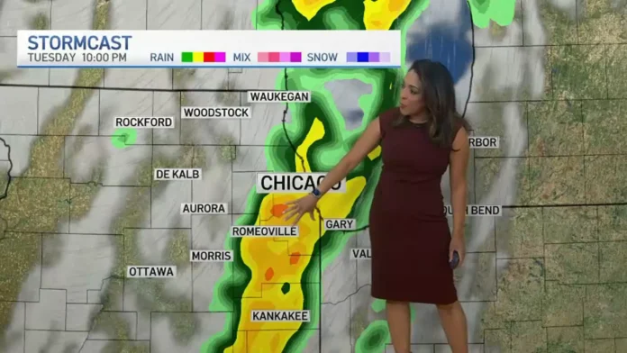
The real threat for storms moves in Tuesday evening. “The best chance to see those showers and storms will really be after 7 p.m. moving from west to east,” Roman said, noting that “all weather hazards are possible.”
From 7 p.m. through midnight, severe storms will likely hit the region, “quickly passing through our evening hours,” Roman said.
7 p.m.
According to early morning projections, the storms will likely start in the western suburbs between 7 and 8 p.m.
9 p.m.
Early projections indicate storms could reach city limits between 9 and 10 p.m., Roman said.
11 p.m.
The storms are expected to hit southern counties and northwest Indiana late Tuesday evening.
12 a.m.
The storms are forecast to move out just before midnight Wednesday.
What to Expect
Roman noted the system is fast-moving and “could definitely pack a punch.”
The entire Chicago area is at an “enhanced” risk for severe weather, a level three threat out of five.
Roman said the biggest threats with the storms will be damaging and destructive winds, with gusts up to 75 mph considered the “primary threat.”
“But tornadoes are also right behind it,” Roman said. “That possible spin up, brief tornadoes [are] possible into the evening hours. A lot of this will be a nighttime while you’re sleeping, so have a way to get alerts on your phone.”
Get severe weather alerts on the NBC Chicago app.
Areas out to the west of the Chicago area could see even more violent winds and a higher threat of tornadoes, with areas around the Quad Cities potentially at a “moderate” risk of severe weather, officials said.
Rest of the Week
After the storms, temperatures begin to cool down with highs in the mid-70s, though the 80s return by the end of the week with another chance for showers.
Stay tuned to the NBC 5 Storm Team for all the latest weather news and information.
Don’t let the hot and dry start to Tuesday deceive you, as a stormy evening may be in the forecast for much of the Chicago area. But fear not, as we have a timeline and all the information you need to prepare for what’s to come.
Tuesday morning is expected to start off mostly dry and hot, with temperatures soaring to 90 degrees in some areas. While there may be a chance for an isolated shower, the majority of the region will remain dry until the afternoon.
As we move into Tuesday afternoon, the heat will continue, with temperatures in the mid-80s. A few clouds may pass through, but overall it will be a dry day. However, storms moving through Iowa may head towards Wisconsin, so keep an eye out for any changes in the weather.
The real threat for severe weather comes in the evening, with the best chance for showers and storms starting around 7 p.m. and moving from west to east. These storms are expected to hit the region quickly, so it’s important to stay informed and have a way to receive alerts on your phone.
The entire Chicago area is at an “enhanced” risk for severe weather, with damaging winds and possible tornadoes being the biggest threats. Areas to the west of Chicago, such as the Quad Cities, may experience even more severe weather, with a “moderate” risk in

